
Overview

Update: October 30 2025
Hurricane Melissa is racing away from the Bahamas and toward Bermuda this morning. A Hurricane Warning is in effect for Bermuda, where tropical-storm winds will arrive this afternoon and hurricane conditions are expected overnight. Melissa is projected to pass about 122 miles northwest of the island near 1 a.m. Friday before gradual weakening begins.
Bahamas and Turks and Caicos
Melissa’s compact inner core threaded through Crooked Island Passage on Wednesday night, bringing peak gusts estimated between 90 to 95 mph and storm surge of four to seven feet to parts of Long Island, Acklins, Crooked Island and Ragged Island. More than 1,400 residents were air-lifted to New Providence under a mandatory evacuation order; localized outages and telecom interruptions persist.
Regional toll and recovery
Haiti’s Petit-Goâve area suffered deadly river flooding, while Jamaica continues wide-scale cleanup with 77 percent of customers still without power on Thursday. Cuba reports no storm-related deaths, though 241 communities in Santiago Province remain cut off and roughly 140,000 residents are still isolated after earlier evacuations of 735,000 people.
Outlook
Melissa should maintain Category 2 strength through tonight, delivering hurricane-force winds up to 75 miles from its eye and dangerous surf for Bermuda and the western Atlantic seaboard. Transition to an extratropical gale south of Atlantic Canada is likely late Friday.
Cotality will continue to monitor Hurricane Melissa and provide further updates as new information becomes available.
Update: October 29, 2025
Hurricane Melissa has weakened after its punishing passage across Jamaica and eastern Cuba but remains a dangerous Category 2 cyclone. At 2 p.m. EDT the center was just south-southeast of the central Bahamas, moving northeast at 15 mph with sustained winds of 100 mph and a central pressure of 974 mb. Hurricane Warnings now cover the southeastern and central Bahamas as well as Bermuda, while Cuba’s eastern provinces remain under warning although conditions there will improve later today.
Landfalls and track
Melissa made its first landfall near New Hope, Jamaica, at about 1 p.m. EDT Tuesday with 185 mph winds, the strongest on record for the island. The storm then crossed the Caribbean and struck near Chivirico in Santiago de Cuba province around dawn Wednesday as a high-end Category 3 hurricane with 120 mph winds before emerging over the Atlantic.
Melissa will traverse the Bahamas this evening with hurricane-force winds extending 40 miles from the eye and storm-surge heights of four to seven feet. Five to ten inches of rain could produce flash floods across the low-lying islands. Slight re-intensification is possible over warm Atlantic waters.
Jamaica
The Prime Minister has declared the entire island a disaster area. Preliminary reports confirm catastrophic wind damage in the western parishes and mountainous flash flooding. Over 500,000 electricity customers remain without power, and more than 15,000 people are sheltering in public facilities.
Capital-markets trigger
Verification of Melissa’s 892 mb landfall pressure in Jamaica satisfies the parametric criteria for Jamaica’s $150 million IBRD CAR Jamaica 2024 catastrophe bond. Investors therefore face a full principal loss that will channel rapid funds to the government once the World Bank’s calculation agent confirms the trigger. Reinsurers are expected to shoulder most insured losses, and aggregate covers across the Caribbean could be pierced.
Cotality will continue to monitor Hurricane Melissa and provide further updates as new information becomes available.
Update: October 28, 2025
Hurricane Melissa has intensified further while pivoting north-northeast and is now roaring ashore on Jamaica with sustained winds of 185 mph and a minimum central pressure of 892 mb, its strongest reading yet. That pressure places Melissa among the most intense storms on record. At 11 a.m. EDT the eye was fixed around 40 miles southeast of Negril, moving north-northeast at 9 mph.
Jamaica is already suffering severe impacts: roughly 240,000 electricity customers are without power and authorities are warning of imminent flash-flooding. Pricing on Jamaica’s $150 million World Bank-sponsored IBRD CAR Jamaica 2024 catastrophe bond has dropped as investors brace for a possible trigger once official wind or pressure readings are finalized.
The latest National Hurricane Center advisory extends a Tropical Storm Warning to the Turks and Caicos Islands and upgrades Cuba’s Las Tunas province to a Hurricane Warning, reflecting Melissa’s expected track across southeastern Cuba tonight and into the southeastern Bahamas on Wednesday.
Cotality will continue to monitor Hurricane Melissa and provide updates as new information becomes available.
Update: October 27, 2025
Cotality estimates damages from Hurricane Melissa between $5 – $10 billion.
Hurricane Melissa has seized the title of the strongest storm of the 2025 Atlantic season, its 165 mph (270 km/h) winds and 908 mb eye driving a stadium wall of cloud only ten nautical miles wide.
Melissa is the third Category 5 hurricane of the year, following Erin in mid-August and Humberto earlier this month. Only one other Atlantic season on record has produced as many storms of this magnitude.
At the latest advisory the center sat about 145 miles (230 km) southwest of Kingston, crawling west at 3 mph but expected to pivot north later today. Hurricane-force winds already sweep 30 miles from the core and tropical-storm gales reach 195 miles, putting much of Jamaica under punishing squalls long before the eye arrives.
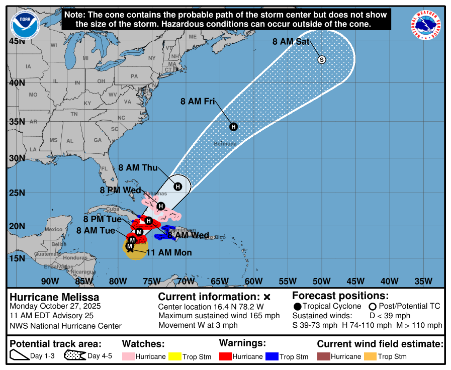
Figure: Hurricane Melissa five-day forecast cone with current watches and warnings, NHC Advisory #25, Oct. 27, 2025. Source: NHC
The forecast track keeps the eye on a slow arc over Jamaica tonight and early Tuesday, then across southeastern Cuba Tuesday night and into the southeastern Bahamas on Wednesday before bending northeast toward Bermuda. Even modest weakening over Jamaica’s terrain would leave Melissa a major hurricane when it re-emerges over water.
Rainfall projections of 15–30 inches, with mountain peaks near 40 inches, threaten catastrophic flash floods and landslides. Life-threatening storm surge of 9–13 feet is expected along Jamaica’s south coast, accompanied by destructive waves. Eastern Cuba faces 15–20 inches of rain and surge of 7–11 feet; southern Hispaniola 8–16 inches; the Turks and Caicos and the southeast Bahamas 4–8 inches plus four to six feet of surge.
Jamaica’s economic exposure is severe. The country’s most recent World Bank tables place nominal GDP near $19.9 billion. A direct Category 5 landfall on the nation’s most populous corridor could significantly strain public finances for years to come. Cotality estimates damages from Hurricane Melissa between $5 – $10 billion.
Reinsurance and capital-markets cushions will be tested. Jamaica’s $150 million World Bank-sponsored IBRD CAR Jamaica 2024 parametric catastrophe bond has already traded down as investors anticipate a trigger should official wind or pressure readings meet the bond’s thresholds. Local insurers retain higher deductibles than before the recent hard market, yet international reinsurers still hold the lion’s share of property-catastrophe exposure. A multi-billion-dollar insured loss, even a mid-single-digit figure in absolute terms, could represent one of the most concentrated reinsurance events ever seen in the Caribbean and could pierce several aggregate covers.
Authorities closed both international airports, opened 881 shelters and issued mandatory evacuation orders for the lowest-lying districts of Kingston, Old Harbour Bay and Port Royal. Residents across the island were urged to move to sturdy shelter by afternoon; after sunset, conditions may become too dangerous for travel.
Melissa’s eyewall is expected to reach Jamaica’s south coast after nightfall.
Cotality will continue to monitor Hurricane Melissa and provide updates as new information becomes available.
Update: October 26, 2025
In the span of a single afternoon, Hurricane Melissa exploded into a Category 4 giant. As of 5 p.m. local time (2100 UTC) on Sunday, October 26, the eye sits only 115 miles (185 km) south-southwest of Kingston, Jamaica, packing sustained winds of 145 mph and a central pressure of 941 mb, numbers that underscore just how quickly this storm has become a serious threat.
Rapid Strengthening
Data from an afternoon Hurricane Hunter flight show Melissa picked up speed again after a short lull. Pressure fell another 12 mb, the eye shrank to only six miles wide, and satellite pictures reveal an almost perfect stadium-shaped eye surrounded by extremely cold cloud tops. Peak flight-level winds of 148 mph and a surface gust of 150 mph back up the current intensity estimate.
Impacts to Jamaica
A Hurricane Warning covers all of Jamaica. Tropical-storm winds are likely already brushing some coastal areas, and full hurricane conditions are expected by Monday. The National Hurricane Center (NHC) is forecasting 15 to 30 inches of rain. Isolated spots could see up to 40 inches, raising the risk of dangerous flash floods and landslides. Storm surge along Jamaica’s south coast could push water 9 to 13 feet above the normal tide while driving powerful, destructive waves ashore.

Figure 1: Hurricane Melissa five-day forecast cone with current watches and warnings, NHC Advisory #22, Oct. 26, 2025. Source: NHC
Path After Jamaica
Melissa is drifting west at just 5 mph, but a sharp turn to the north and then northeast is expected Monday as steering winds change. The official track brings the center directly over Jamaica late Monday night or early Tuesday, through southeastern Cuba on Tuesday night, and into the southeastern Bahamas on Wednesday. Mountain terrain will likely knock the winds down a bit, yet the storm should stay strong enough to be a major threat through its Cuban landfall.
Wind and Rain Footprint
Hurricane-force winds stretch up to 30 miles from the eye, and tropical-storm winds reach almost 205 miles out. Eastern Cuba could receive 10 to 15 inches of rain, with pockets approaching 20 inches. Southern Hispaniola may see 8 to 16 inches, and the southeastern Bahamas 4 to 8 inches plus surge. Large, dangerous swells are already rolling into Hispaniola, Jamaica, eastern Cuba, and the Cayman Islands and will build across the Bahamas and eventually Bermuda.
Cotality will continue to monitor Hurricane Melissa and provide updates as new information becomes available.
